The automatic identification system (AIS) is an automatic tracking system that uses transceivers on ships and is used by vessel traffic services (VTS). When satellites are used to receive AIS signatures, the term Satellite-AIS (S-AIS) is used. AIS information supplements marine radar, which continues to be the primary method of collision avoidance for water transport. Although technically and operationally distinct, the ADS-B system is analogous to AIS and performs a similar function for aircraft.
Information provided by AIS equipment, such as unique identification, position, course, and speed, can be displayed on a screen or an electronic chart display and information system (ECDIS). AIS is intended to assist a vessel's watchstanding officers and allow maritime authorities to track and monitor vessel movements. AIS integrates a standardized VHF transceiver with a positioning system such as a Global Positioning System receiver, with other electronic navigation sensors, such as a gyrocompass or rate of turn indicator. Vessels fitted with AIS transceivers can be tracked by AIS base stations located along coastlines or, when out of range of terrestrial networks, through a growing number of satellites that are fitted with special AIS receivers which are capable of deconflicting a large number of signatures.
Terrestrial-based AIS (T-AIS)
AIS was developed in the 1990s as a high intensity, short-range identification and tracking network. Shipboard and land-based AIS transceivers have a horizontal range that is highly variable, but typically only up to about 74 kilometres (46 mi). Approximate line-of-sight propagation limitations mean that terrestrial AIS (T-AIS) is lost beyond coastal waters. In addition to port and maritime authority operated transceivers, there is large network of privately owned ones as well.
Satellite-based AIS (S-AIS)
In the 1990s AIS was not anticipated to be detectable from space. Nevertheless, since 2005, various entities have been experimenting with detecting AIS transmissions using satellite-based receivers and, since 2008, companies such as L3Harris, exactEarth, ORBCOMM, Spacequest, Spire and also government programs have deployed AIS receivers on satellites. The time-division multiple access (TDMA) radio access scheme used by the AIS system creates significant technical issues for the reliable reception of AIS messages from all types of transceivers: Class A, Class B, Identifier, AtoN and SART. However, the industry is seeking to address these issues through the development of new technologies and over the coming years the current restriction of satellite AIS systems to Class A messages is likely to dramatically improve with the addition of Class B and Identifier messages.
Satellite Automatic Identification System (S-AIS) is a technology that uses satellites to track the location of vessels globally, extending the range of traditional AIS systems beyond the horizon and providing a broader view of maritime traffic.
How it works:
Satellites equipped with S-AIS receivers detect and collect AIS signals from vessels, even those far from shore, and relay this data to ground stations for processing and distribution.
Benefits:
- Global Coverage: S-AIS overcomes the limitations of traditional AIS, which has a range of about 40 nautical miles, providing a global view of maritime traffic.
- Increased Maritime Situational Awareness: S-AIS enables better tracking and monitoring of vessels, leading to enhanced safety and efficiency in maritime operations.
- Enhanced Search and Rescue: S-AIS can be used to locate vessels in distress, even in remote areas, facilitating faster and more effective search and rescue operations.
- Improved Maritime Security: S-AIS can help authorities monitor maritime traffic and detect suspicious activity, contributing to enhanced maritime security.
- Environmental Protection: S-AIS data can be used to track vessel movements and detect potential pollution incidents, aiding in environmental protection efforts.
Applications:
- Fleet Monitoring and Management: S-AIS data can be used to track the location and movements of vessels in a fleet, improving efficiency and reducing costs.
- Collision Avoidance: S-AIS data can be used to predict potential collisions and take preventative measures.
- Maritime Security: S-AIS data can be used to monitor maritime traffic and detect suspicious activity, contributing to enhanced maritime security.
- Search and Rescue: S-AIS can be used to locate vessels in distress, even in remote areas, facilitating faster and more effective search and rescue operations.
- Improving Shipping/Routing Strategies: S-AIS data can be used to optimize shipping routes and improve fuel efficiency.
- Fleet Performance Analysis: S-AIS data can be used to analyze the performance of a fleet and identify areas for improvement.
Recent news
As you may know, Spire Global reported in Nov 2024: it’s selling the maritime business unit to Kpler. However, Kpler sued for USD 241m for delaying acquisition. According to a filing from the plaintiff Spire Global, Kpler has cited several reasons why the deal has not been completed. Spire Global has rejected all of them.
Spire is a satellite data subscription business. It builds, owns, and operates ~100 satellites that collect RF data for maritime (tracking ships), aviation (tracking planes), and weather (tracking the atmosphere) uses. Customers subscribe to data feeds, not unlike how you subscribe to Bloomberg.
People like to think of Spire as a satellite operator, but no satellites are changing hands in this deal. Spire is selling a $40M book of business, exclusive rights to a contract with L3Harris (granting access to real-time AIS data from an Iridium Next AppStar payload), software IP, and dedicated employees. Much of what will be sold was acquired three years earlier for $129M (exactEarth).
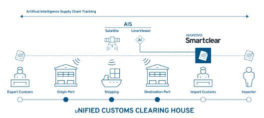
HAKOVO's AIS data source collaborates with IHI Corporation, which holds exclusive rights to exactEarth data in the Japanese market. This partnership enables real-time tracking of vessels worldwide, even down to individual bill of lading (BL) levels.